History and Overview of Grand Turk
Grand Turk is an island in the country of Turks and Caicos, which is a British Overseas Territory located in the tropical Atlantic Ocean between the Bahamas and the Dominican Republic.
Grand Turk is the historical center of the Turks and Caicos. It is the second most populated island in the country after the island of Providenciales, and is home to the capital city of Cockburn Town.
Grand Turk is located on the eastern end of the Turks and Caicos archipelago, and—along with the nearby island of Salt Cay—is divided from the other main islands in the country by the deep Columbus Passage. In the last 20 years, Providenciales has largely replaced Grand Turk as the primary site of government and commerce in the nation.
| Quick Facts | |
| Population | 4,831 (2012 Census) |
| Area | 6.9 mi² (18 km²) |
| Airport | Grand Turk Airport (GDT) |
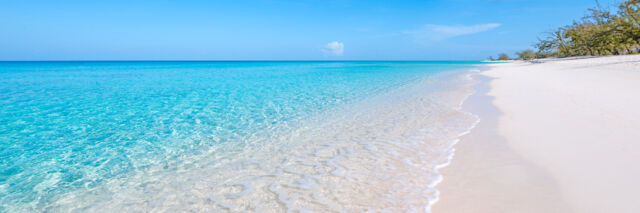
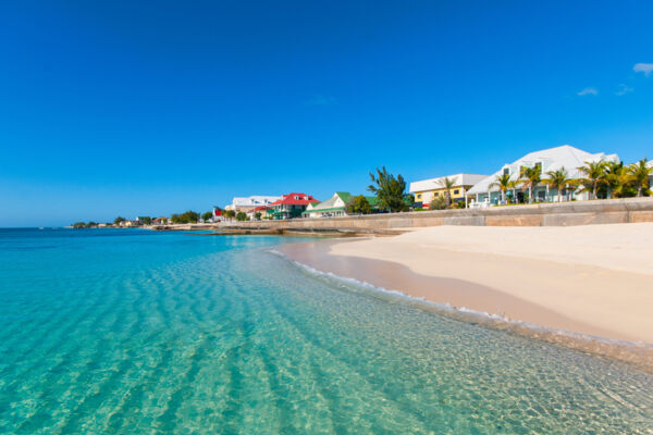
| Best Beach | Governor's Beach |
| Highest Point | 89 feet (27 m) - Colonel Murray’s Hill |
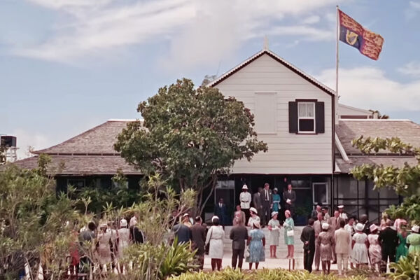
Originally founded by settlers from Bermuda as a site for sea salt production in 1681, Cockburn Town on Grand Turk has been the official capital of the Turks and Caicos since 1766. Many of the country’s main government offices, including the main Supreme Court bench and the Governor’s official residence, can be found here. Despite this, the Governor primarily resides on Providenciales now (where most Ministers live and where Cabinet usually meets), and the Supreme Court has additional benches on Providenciales.
Several important historic events have taken place or are thought to have occurred around this small island. Grand Turk was likely the location of Christopher Columbus' first landfall in the New World in 1492. In 1962, Grand Turk was the first dry land that American astronaut John Glenn stepped foot on after orbiting Earth.
History
The Lucayans (a Taíno-language people) are believed to have been Grand Turk's first inhabitants. Historians suspect that these people migrated to the Turks and Caicos (from South America and via the Caribbean islands) around the year 700 AD. Grand Turk never had the populations of Lucayans that North Caicos and Middle Caicos did, yet the island did support some small fishing communities.
Grand Turk is also considered by some historians to be Christopher Columbus’ first point of landfall in the New World. There is a strong case for this theory, as of the two main candidate islands—San Salvador in the Bahamas and Grand Turk—Grand Turk's terrain best matches Columbus’ account of a “bean-shaped” island with central ponds. The lush vegetation described in original accounts may have been dense red mangrove forests in the central salinas, which likely existed before the advent of the salt production days and would have been a verdant green. Such mangrove systems are still found in the Caicos Islands, and can reach heights approaching 30 feet (9 m).
Early into the 1500s, the Lucayan population disappeared due to disease and slavery, and the Turks and Caicos remained largely uninhabited for about a century. During this period, loose control passed between pirates, the Spanish, the French, and the British.
Sea Salt Industry
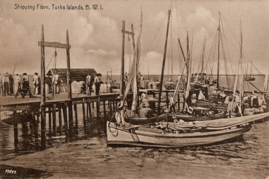
Sea salt production is what initially put Grand Turk on the map. Many islands in the Turks and Caicos have shallow saltwater ponds, and these ponds—occasionally replenished by abnormally high tides—would naturally produce sea salt due to evaporation.
Sometime near the end of the 1600s, British colonialists from Bermuda recognized the potential of the ponds, and the salt industry began. The ponds were developed into salinas with low stone dividing walls splitting the brine into different stages of salinity. Windmill pumps and gates controlled ocean water input and movement.
Production peaked at the start of the 1900s, when over 227 acres (92 hectares) of salinas were being used on the island. At the height of production, about two million bushels (140 million pounds, or 64 million kilograms) of salt were being shipped from the country annually.
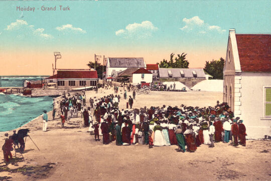
The capital of the Turks and Caicos, Cockburn Town, formed naturally over the centuries.
US Bases
The modern era saw a shift in the economy of Grand Turk. The local salt industry was dying due to the inefficiencies of the small scale of production, and the economic outlook wasn’t promising.
In the 1950s, Grand Turk saw a bit of increased activity with the construction of two US bases. On the northern coast near the lighthouse lies the ruins of Grand Turk's US Navy NAVFAC 104 Base. This base was used for the US Navy's Sound Surveillance System (SOSUS) program during the Cold War.
Also built at around the same time was South Base, the US Air Force missile tracking station and airport. South Base operated for a few decades until it was decommissioned in 1983. The runway became the Grand Turk JAGS McCartney International Airport (GDT), and many adjacent buildings were repurposed for local government use.
After orbiting Earth in 1962, Lieutenant Colonel John Glenn’s capsule Friendship 7 touched down in the Atlantic Ocean east of the Turks and Caicos. After being picked up by the American destroyer USS Noa, John Glenn’s first step on dry land took place on Grand Turk.
Sights and Attractions
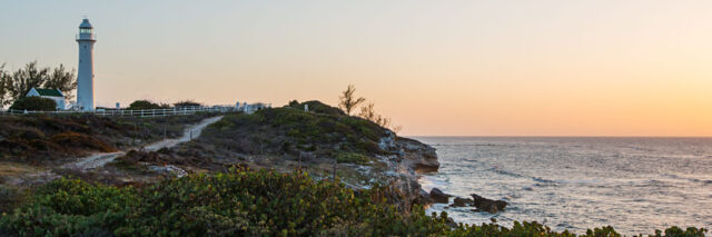
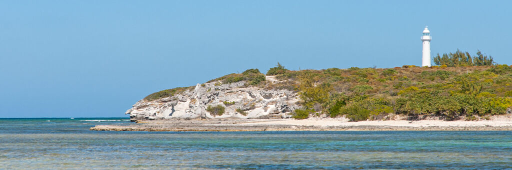
The most famous landmark in the Turks and Caicos is the Grand Turk Lighthouse. The only lighthouse in the country, it was prefabricated in England and built in 1852.
The lighthouse was initially set up to burn whale oil for light, but over time was converted to kerosene and finally electricity in 1971. The lighthouse is no longer operational, although the surrounding grounds are open to the public.
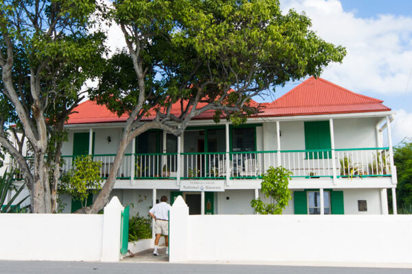
Another site for the historically inclined is the Turks and Caicos National Museum located on Front Street. There’s a wealth of fascinating displays here, including a 500–800-year-old Lucayan carved wood duho (a ceremonial chair) and artifacts from the Molasses Reef Wreck, which is the oldest European shipwreck excavated in the Western Hemisphere.
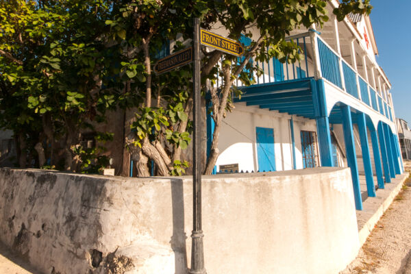
Many of the older buildings on Grand Turk reflect the colonial British-Bermudian heritage, with their cut stone block construction and smooth stucco finish. This architecture is best seen on Front Street and Duke Street in old Cockburn Town, and a few of the old homes may be rented as vacation villas.
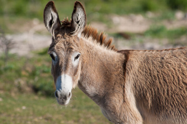
Donkeys and horses, first introduced in the salt industry days as a means of transportation, can still be seen roaming freely.
Grand Turk is known for its scuba diving and offshore snorkeling, with pristine and sheer wall sites defining the underwater experience. In many places, the wall can drop from 30 feet (9 m) to over 7,000 feet (2,134 m). The island supports a laid-back dive culture, with a few shops on the island running small tours of 10 or fewer divers.
The Columbus Landfall National Park, which marks the presumed landfall site of Christopher Columbus, is located on the western coast of the island and is named after the explorer.
Many beautiful beaches are found in this protected area, including Cockburn Town Beach, Governor's Beach, and the Cruise Center Beach.
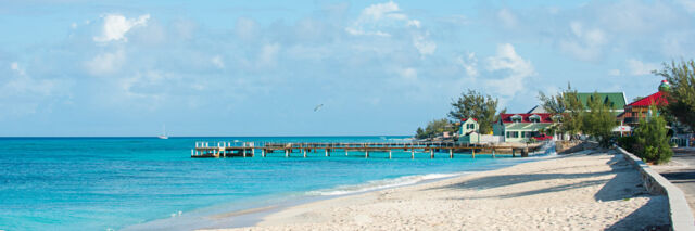
The Cruise Center
A relatively recent addition (historically speaking) to Grand Turk is the Grand Turk Cruise Center on the southern end of the island. This facility was opened in 2006 by Carnival Cruise Line as a stop for ocean liners and as a base of operations for cruise ship visitors, who account for the majority of annual visitors to the Turks and Caicos Islands, according to tourism statistics.
Many jewelry and gift shops, restaurants, bars, and attractions are located here, along with swimming pools for cruise ship guests.