
Exploring Salt Cay
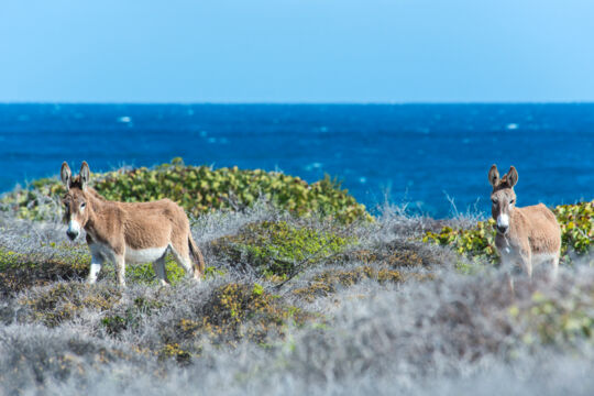
The tiny island of Salt Cay is mainly known today for its excellent whale watching and diving, yet exploring the landscapes and old ruins is just as interesting. Donkeys and cattle, descendants of the animals worked during the salt days, can be seen across the island.
Although Salt Cay is quite small, it’s always possible to get away from it all and have your entire surroundings to yourself.
Landscapes and Scenery
Close to the Deane's Dock and Balfour Town area is the high ground of Little Bluff Lookout. A single, modernly placed cannon (possibly from the HMS Endymion wreck) overlooks the Columbus Passage between the Turks Islands and the Caicos Islands. Great panoramic views can be had over the whole of Salt Cay and on most days, cruise ships can be seen on the horizon heading to and from Grand Turk.
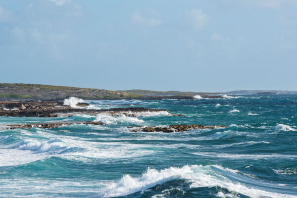
South Wells and South Point are two more places you don’t want to miss. The entire tip of the island only has low-level coastal vegetation and the heads of alert donkeys and cattle popping up through the bushes can be spotted. On stormy and rough days, it’s interesting to see the contrast between the ocean swells off the east side of South Point and the sheltered west side. The best seashell beachcombing can be found on the coasts in this area.
Found on the central east side of the island, the deserted Taylor Hill has the weathered ruins of the old whaling lookout and station. Below the high ground is Long Bay. Here, a newly wrecked fishing boat can be seen on the reef nearby and the beach offers excellent flotsam beachcombing.
As remote as it gets on the island, Northeast Point offers views of Grand Turk, Cotton Cay, and beautiful Salt Cay coastlines. An excellent hike is to follow the coast southeast as the hills in this region offer scenic views over much of Salt Cay.
The wetlands, mangroves, and sandy channels of South Creek are a great place for watching some of the larger birdlife. Much of South Creek has a clean sandy bottom (not soft mud!) so it’s possible to wade through the shallow water to get out to the rocky shoreline in the area.
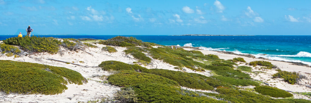
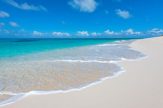
No overview of Salt Cay landscapes would be complete without mentioning North Bay. By far the best beach on the island, pristine white sand and clear water can be found here. The abandoned Windmills Hotel can also be seen in this area, but the interior should be avoided due to serious structural damage caused by Hurricane Ike in 2008.
Whale Watching
When in season (January through April) Salt Cay is a great place for Humpback Whale Watching. Although a dedicated whale watching boat excursion will almost always give you the best experience, it’s often possible to spot whales from shore on Salt Cay during migration season. The higher areas overlooking deeper water are the likeliest locations for sightings, with the best being either Taylor Hill, Long Bay, or Northeast Point.
Flat ocean conditions make it much easier to spot whales, and decent binoculars are great to have.
The Salinas
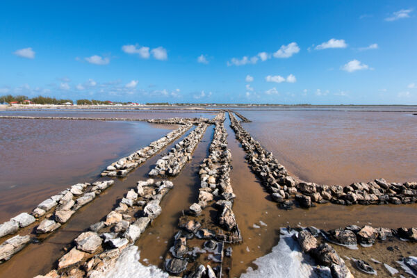
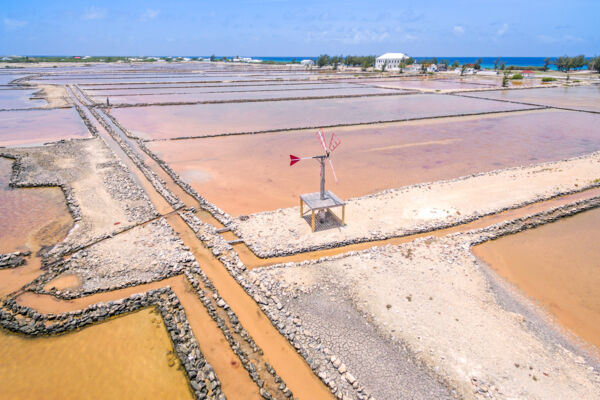
Although the process of producing salt by evaporating seawater might appear a bit primitive, by the mid-1700s the Bermudians had a complex and efficient system going. As the water evaporated and the salt content progressively increased, the brine would be moved up through different stages of ponds until it crystallized. This method allowed for more constant production and largely avoided the setback that wall failure or an abnormally high tide might cause.
After the brine became the solid crystals that everyone recognizes today, it would be raked by hand, moved by bushel basket and donkey cart, and finally filled into sacks for export.
In their former days of operation, all of the sluice gates and dividing walls would be generally waterproof and capable of either holding water in or out. Windmills stood at most of the more complex dividing wall junctions and were used to power simple bucket wheel and Archimedean screw-type pumps.
The best of walls and sluice gates can be seen today on the Town Salina right off the main road that connects the Deane’s Dock area with South District.
The Buildings
There are several rather small districts on Salt Cay.
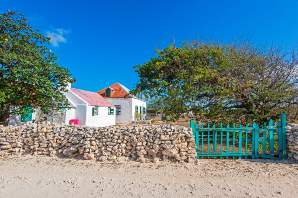
As with Grand Turk, the older structures on Salt Cay are heavily influenced by the colonial Bermudian-style. Large blocks of the soft native limestone were cut and fitted with surprising accuracy to build the one and two-story houses, old docks, and the more important inlet channels and gates for the salina systems. Most of the homes and warehouses would then get a coat of smooth stucco to protect the walls and keep the interiors free of the white limestone dust that would otherwise be a constant problem.
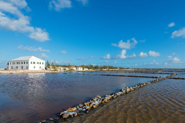
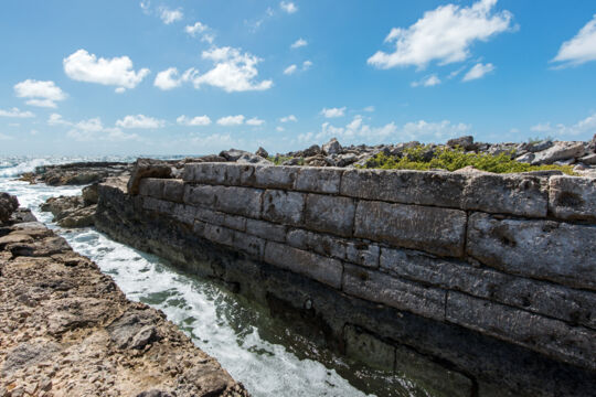
The most iconic of the Salt Cay structures, the White House was originally built in the late 1820s and was the center of operations, salt storage, and residence of the Harriott Family. Although the building still stands today and appears relatively sound, it’s uninhabited and in need of repairs. Battered by a century of waves and storms, the stonework of the pier and salina inlet on the ocean side of the White House shows the effort colonial Bermudians put into the salt industry.
Very few of the original buildings remain in decent condition today. Many were modified to varying degrees as the years went by and others were allowed to fall into ruin.
Although not extensive, another beautiful example of stonework can be seen at the inlet to Grey Salina on the northeast coast. Eroded away below the water level, these walls still do their intended job.
Routes and Distances
At only 3 by 1 mile (4.8 by 1.6 km) in size, Salt Cay is a very small island. There are three common modes of transportation on the island: walking, cycling, and off-road golf carts.
For active hikers, it’s possible to see all the major sites in one day, however, this will likely be quite exhausting. Allowing an extra day or two if on foot or renting a bicycle or golf cart will make for a much more relaxed experience. Be sure to consider that the sun is usually intense and bring plenty of water to drink. See Getting Around Salt Cay.
)