
Turks and Caicos Mangroves
The Turks and Caicos is home to many varied marine and terrestrial environments, yet one of the most important, and one that often ties land and sea, is the mangrove wetland.
Mangrove is a term that globally can refer to more than 80 species of salt-resistant trees. In the Turks and Caicos, red mangroves (Rhizophora mangle) are by far the most common, followed by black mangroves (Avicennia germinans) and white mangroves (Laguncularia racemose). Silver buttonwood (Conocarpus erectus), which is also common in the archipelago, is sometimes referred to as button mangrove or false mangrove.
Mangroves are halophytes, which is a term for plants that have a high tolerance for salt. The mangrove root system can effectively filter out salt as the water is absorbed into the roots through a process similar to reverse osmosis, and excess salt that is absorbed is accumulated in the leaves, and as the leaves naturally die and are replaced, the salt is expelled from the plant.
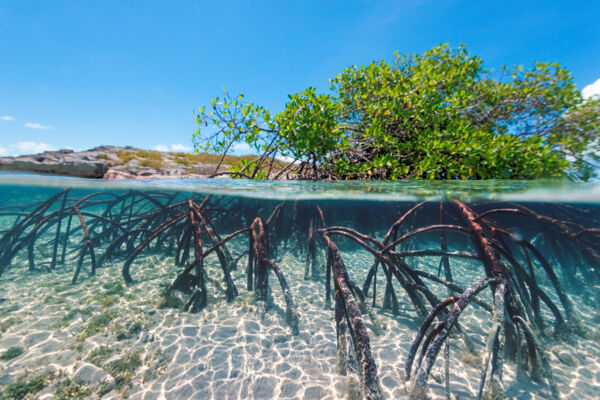
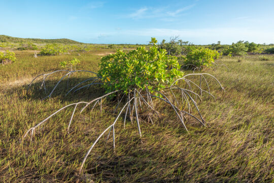
A defining feature of the red mangrove is its aerial prop root system, which is often exhibited as sprawling from the main trunk of the tree, and which is often partially exposed above the ground or bottom of the water that the tree is growing in. Red mangroves get their name from their reddish-brown sap and softwood, which can be seen when branches are cut or bruised. The trees are evergreen, with bright green and broad leaves.
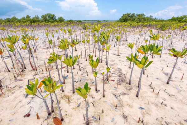
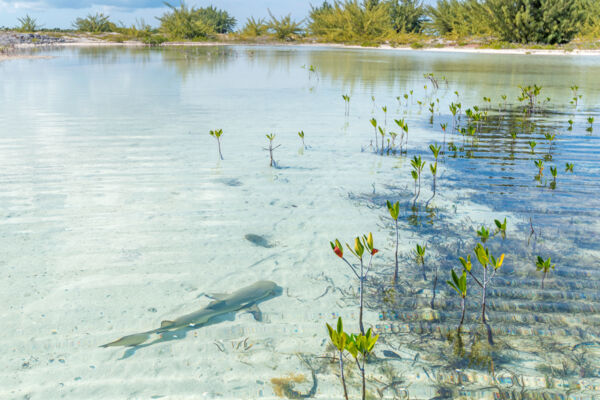
The red mangrove has small yellow flowers, and produces unique seeds which become propagule seedlings that float and may become established on coasts and beaches. In the Turks and Caicos, red mangroves can potentially be found anywhere there is standing water or damp ground that the propagules may be washed to, including inland sites that are only submerged by atypical storm surges and flooding. One of the more interesting such places where red mangroves are extant in the islands is the interior limestone coppices of Middle Caicos, where red mangroves can be seen growing directly adjacent to the Caicos pine, and a long distance from the ocean.
In the Turks and Caicos, red mangroves typically do not reach significant heights, and rarely exceed 15 feet (5 meters). Notable exceptions include the heavier growth in the Northwest Point Pond Nature Reserve on Providenciales, the Lorimer’s Point Pond on East Caicos, and isolated stands in the Ramsar Nature Reserve.
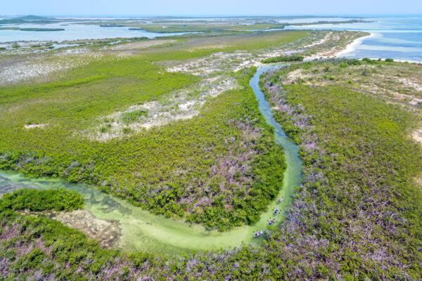
Mangrove wetlands and tidal channels are found throughout the Turks and Caicos, yet are especially prevalent off the southern and western coasts of the Caicos Islands. The islands of Providenciales, North Caicos, Middle Caicos, and East Caicos support the majority of the mangrove populations in the country, yet every island of significance in the archipelago has some red mangroves, typically on the sheltered lee coastlines.
The Importance of Mangroves to the Environment
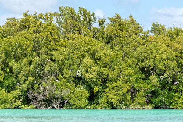
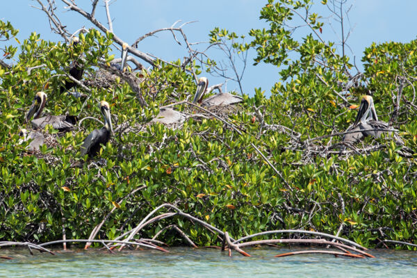
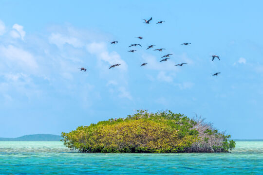
The red mangrove is one of the most important plants in the Turks and Caicos environment. The complex aerial prop root systems of the mangroves protect coastlines from erosion, shelter marine life, and create an environment that supports an array of smaller flora, which in turn supports other fauna, such as juvenile fish. Much of the land mass in the Turks and Caicos is exposed to high salinity ocean water, or has relatively high concentrations of salt, and mangroves and other halophytes provide important vegetation cover where few other plants would grow.
The mangrove-lined tidal channels in the Turks and Caicos effectively act as nurseries for an array of life. The mangrove canopies shelter many types of birds, and it’s not uncommon to find rookies for birds such as the brown pelican, yellow-crowned night heron, reddish egret, and more. Underwater in the complex prop roots, crabs, fish, snails, spiny lobsters, and juvenile turtles can find shelter.
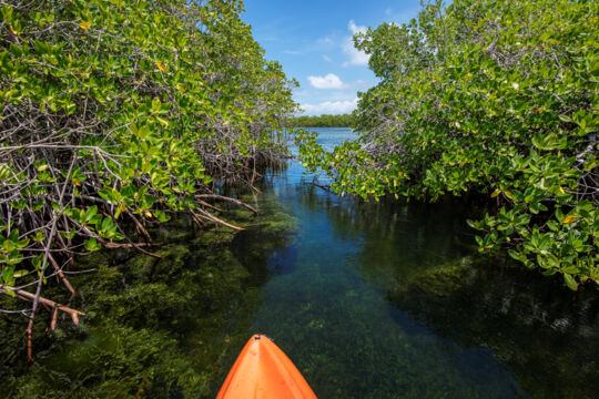
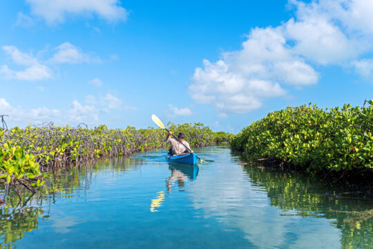
Snorkeling in channels that have verdant mangrove populations, such as the primary channel leading into Mangrove Cay, can be a very rewarding experience, as there’s typically far more to see than may be initially thought.
Threats to Mangrove Populations in the Turks and Caicos
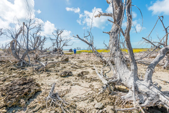
The greatest threat to mangrove populations in the Turks and Caicos is likely development. Unfortunately, many questionable planning and development decisions are made, often without considering pertinent and basic information.
An example is the proposed reductions to the Frenchman's Creek and Pigeon Pond Nature Reserve on Providenciales. This protected area combines microcosms of many of the terrestrial and coastal environments that define the Turks and Caicos, including wetland systems of varying salinities. Included in the many proposed reductions is approximately a 1 mile (1.6 km) section of a complex 2.4 mile (3.9 km) long tidal wetland system, which on its southern end supports what is likely the largest conterminous red mangrove stand on Providenciales. Government departments tasked with providing essential data on the significance of the areas being removed returned maps that did not show that wetlands even existed, let alone data on the importance of the system. Despite widespread public disapproval of the proposed reductions, and despite various government administration changes, what appears to be an unnatural pressure continues to push for the significant reductions to the nature reserve.
Protected Areas
Much of the protected area in the Turks and Caicos includes mangrove wetlands. One of the remarkable aspects of the various wetlands in the country is how much they vary. Differences in tidal movement, water salinity, proximity to reefs and deep water, soil, sand, and rock bedding depths, and more factors into wildlife presence and density.
Ramsar Nature Reserve
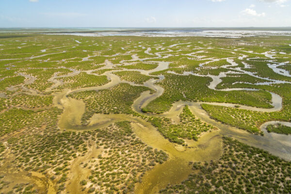
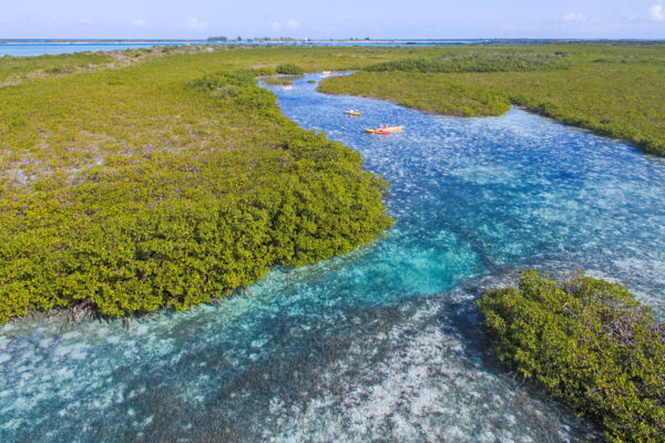
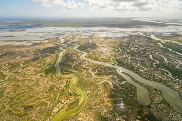
Foremost, by collective area as well as significance to the environment, is the Ramsar Nature Reserve, which is primarily found off of the southern coasts of North Caicos and Middle Caicos, and the south-western coast of East Caicos. This extensive wetland system contains the vast majority of red mangroves in the Turks and Caicos.
It’s fascinating how channels and wildlife present vary across the nature reserve. The North Caicos regions of the Ramsar Nature Reserve tend to have the lowest salinity levels due to rainfall patterns on North Caicos, which can be seen and smelled in the water. The channels leading from Middle Caicos and East Caicos are typically shallower and clearer.
Frenchman’s Creek and Pigeon Pond Nature Reserve
The Frenchman’s Creek and Pigeon Pond Nature Reserve is the largest terrestrial protected area on Providenciales, and one of the most varied protected areas in the Turks and Caicos. Inside the nature reserve are significant populations of all native mangrove species in the Turks and Caicos.
The area excels as a place to see the many environments and terrains where mangroves can thrive. On the sheltered and shallow beaches off the west coast, new growth from propagules can be seen. Several large channel systems lead into the nature reserve between the sandy barrier islands, and these channels are lined by dense red mangroves. In the interior lagoons, red mangrove, black mangrove, and white mangrove stands abound. In the interior wetland flats, isolated patches of mangroves and silver buttonwood trees begin transiting to tropical dry forests. Across all of the zones and in small unique pockets of growth, large numbers of wildlife can be found.
Princess Alexandra Nature Reserve
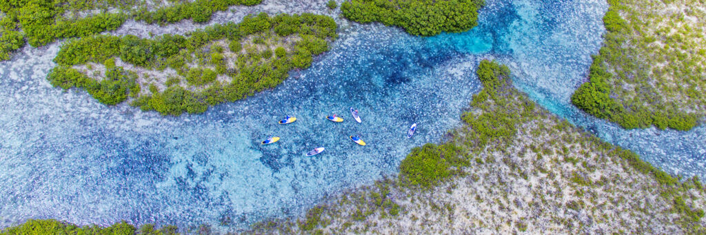
The Princess Alexandra Nature Reserve, which is inside the greater Princess Alexandra National Park, includes the islands of Mangrove Cay, Donna Cay, and Little Water Cay, and is one of the more appreciated wetland regions in the Turks and Caicos.
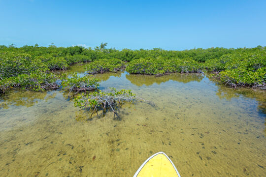
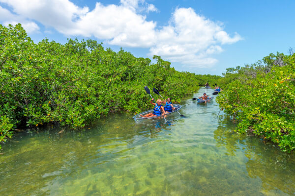
The primary tidal channel on Mangrove Cay, although very limited in extent compared to nearly all other tidal channels and estuaries in the archipelago, likely sees more visitors than any other location. This is due to its proximity to Providenciales, and on most days, many kayakers and paddleboarders make the short hop across Leeward Going Through Channel to see turtles, jellyfish, conch, stingrays, sharks, and birdlife.
Northwest Point Pond Nature Reserve

The Northwest Point Pond Nature Reserve is an isolated pond system on the remote western coast of Providenciales. Several factors make the nature reserve a fascinating place. The pond consists of two parts, an inner pond of about 37 acres (15 hectares) that is completely surrounded by dense red mangroves, and an outer shallow and muddy pond that is adjacent to the coast. Walls of mangroves divide the two systems, yet both are the same body of water.
The interior pond is especially unique, as some of the densest red mangrove forests in the country edge the pond. The pond is tidal, with complex underwater cave systems that can have significant tidal flow.
The red mangrove forests that border the eastern, southern, and western sides of the inner pond in many areas have a high upper canopy, and the interior of these denser forests shelter a broad array of birdlife and crustaceans.
East Bay Islands National Park
The East Bay Islands National Park mainly consists of two barrier islands, Bay Cay and East Bay Cay, off the north-eastern coast of North Caicos, and this scenic area is home to expansive red mangrove systems, including mangrove-lined tidal channels, flats that support dense networks of the trees, and sheltered beach locations that have isolated stands, some of which that exceed 20 feet (6 meters) in height.
The south-westerns sides of the East Bay Islands, which are sheltered and adjacent to Bottle Creek Lagoon, have shallows that have low-density stands of red mangroves, and very little other significant vegetation.
Chalk Sound National Park
Chalk Sound is best known for its iconic turquoise water and picturesque limestone ‘ironshore’ islands, yet the national park also supports significant numbers of red mangrove, especially on the western side of the park. Mangrove densities are highest near the lagoon’s inlet to the ocean on the Caicos Banks, and the channel that leads in.
Dick Hill Creek and Bellefield Landing Nature Reserve
The Dick Hill Creek and Bellefield Landing Nature Reserve is often overlooked, despite being somewhat accessible from Providenciales by boat. The system includes a beautiful and winding tidal estuary lined with red mangroves, and interior flats. Bird sightings can be quite good in the nature reserve.
Eco-tours and Visits to the Wetlands
The Turks and Caicos is best known for its spectacular marine environment and beaches, and the verdant and beautiful mangrove wetlands are certainly part of the attraction. Due to the type of tourists that naturally gravitate to the various islands in the Turks and Caicos, wetland tourism use varies.
The island of Providenciales welcomes nearly all overnight guests that visit the country, and casual level kayak and paddleboard eco-tours are quite popular and support many small businesses. A significant proportion of these eco-tours visit Mangrove Cay, which has raised questions of making other areas accessible. Providenciales has seen a rise in tours that operate clear ‘glass bottom’ kayaks, which have proven to be quite popular.
The quiet central islands of North Caicos and Middle Caicos support relatively small populations, and attract correspondingly few visitors, and generally those seeking nature, seclusion and outdoor activities. The extensive wetlands surrounding the two islands tend to see limited sport fishing for bonefish, extended kayaking eco-tours, camping, and birdwatching.
South Caicos experiences similar tourism demographics to North Caicos and Middle Caicos, often attracting those that enjoy nature and limited development. Being on the eastern edge of the Caicos Banks, the wetlands and channels around South Caicos offer a unique and interesting atmosphere, with high densities of marine and birdlife.
Grand Turk is the only island in the Turks and Caicos that has a cruise ship port, and wetland eco-tours are unsurprisingly less strenuous and of shorter duration, to cater to the limited shore visits times and broader array of fitness levels of guests.