
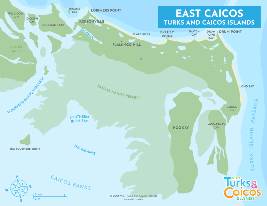
Discover East Caicos
East Caicos is the largest uninhabited island in the Turks and Caicos, and has an area of roughly 32 square miles (83 km²). The island is located between Middle Caicos and South Caicos, and was once the site of guano mining, sisal plantations, and cattle ranches, circa the late 1800s.
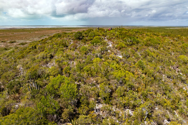
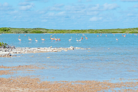
Today, East Caicos is valued as a sanctuary for its rich biodiversity of flora and fauna, particularly endemic Turks and Caicos plants. Nearly all endemic local plants, many of which are considered endangered, are extant on the island. Threatened and protected birds, including the piping plover, West Indian whistling duck, and Caribbean flamingo, are known to have a significant presence on the island and in its ponds.
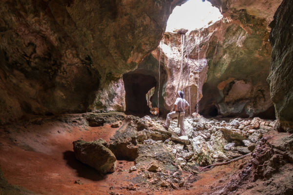
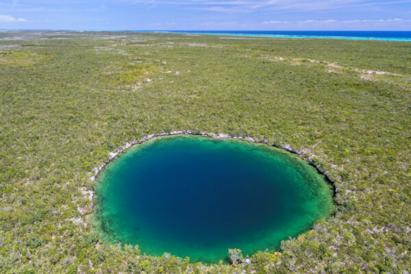
Another area of environmental importance is the island’s karst cave features, which include the second-largest dry cave system and one of the largest blue holes on land in the Turks and Caicos.
The island has largely been uninhabited for the last 100 years, excepting two comparatively short stays in the mid-1900s by settlers seeking to create a new utopia.
Environment and Geology
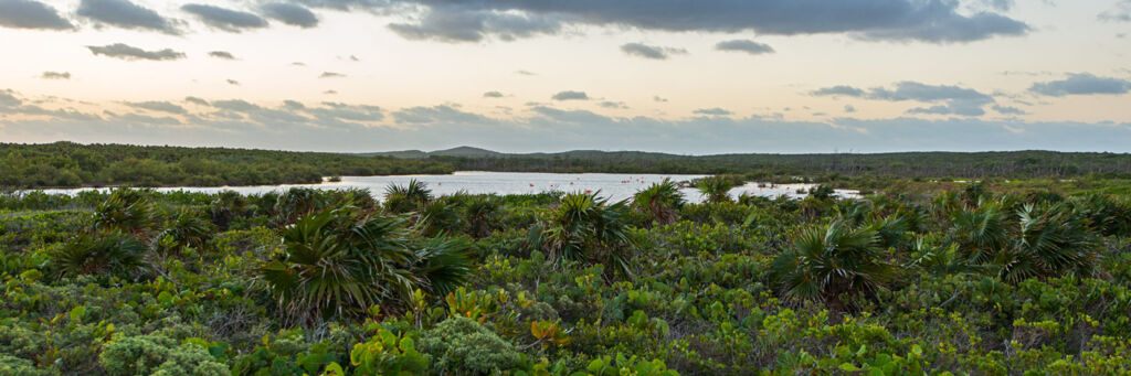
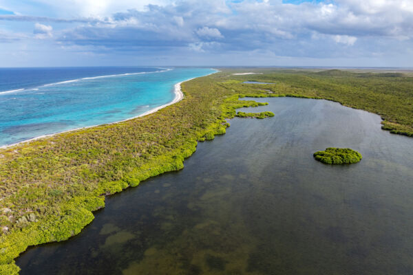
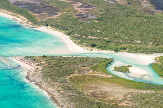
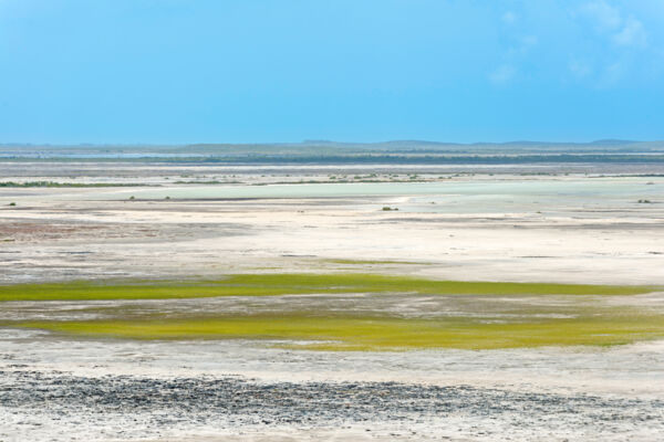
East Caicos is home to a varied and unique environment. About half of the island consists of flat saline tundra and mangrove wetlands, with much of the remainder being low tropical dry forest, thatch palm dunes, silver buttonwood groves, and the occasional freshwater or brackish water pond. The island’s north and east coasts are almost completely beach, collectively over 10 miles (16 km). The southern half of the island is largely wetlands, tidal flats, bare limestone tundra, and red mangroves.
Several extensive and scenic cave systems are found on East Caicos, and although not quite as large as the Conch Bar Caves system on Middle Caicos, they are visually impressive and more complex. Bats and owls thrive in the caves, and the occasional objects left by 1800s-era guano miners can still be seen. The island is also home to more blue holes than any other island in the country, especially when compared to island mass. These blue holes vary quite a bit in size. One 200-foot (60 m) diameter example, found nearly one mile (1.6 km) from the coast, has barracudas and other open-water fish living within it.
There’s a wonderful diversity of landscapes on East Caicos. Small brackish water ponds surrounded by sabal palms are sprinkled across the central plains, extensive saline tundra covers much of the southern side of the island, and coastal cliffs stand at Drum Point, the extreme northeastern point of the island.
History
Taínos
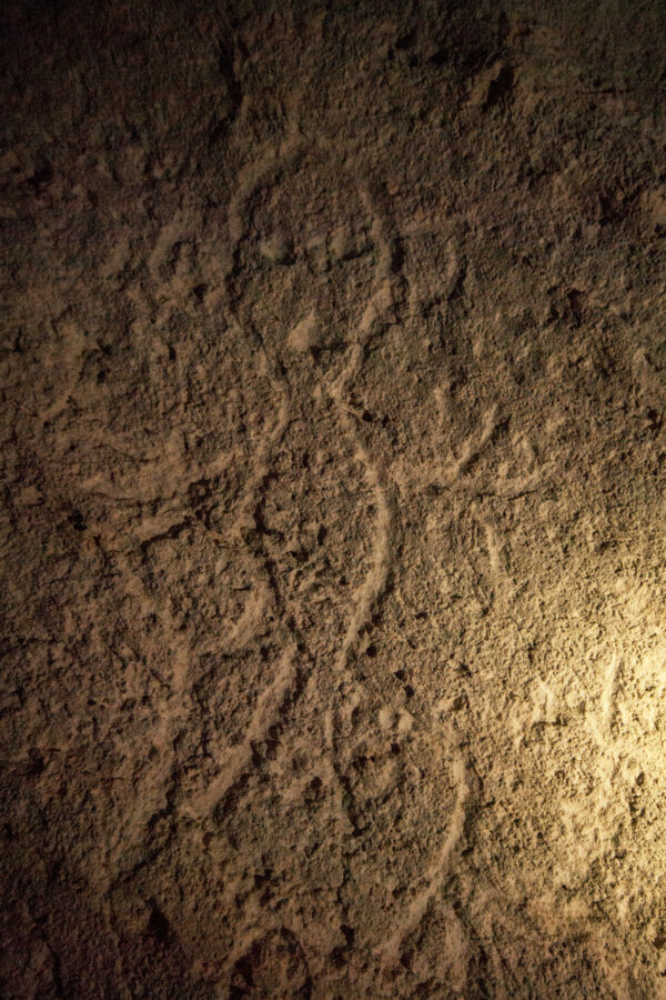
There isn't much recorded history about East Caicos before the 1800s, yet it is known that Taíno natives (also known as Lucayans) lived on the island. According to research by famed early 20th-century explorer and anthropologist Theodoor de Booy, Middle Caicos and East Caicos supported the largest Taíno populations in the entire Bahamas—Turks and Caicos archipelago.
During his visits to the island, Theodoor de Booy made records of Taíno petroglyphs found in some of the caves on the island. The whereabouts of these carvings were subsequently lost until recently, when a few were rediscovered by local photographer and writer Kim Mortimer and later on by a team sponsored by the Turks and Caicos National Museum.
Unfortunately, there is very little known evidence of pre-Columbus Taíno history on the island beyond these small inscriptions and isolated fishing and gathering sites.
The Trouvadore
One incident of importance that happened just off the coast of East Caicos was the wrecking of the Spanish slave ship Trouvadore, which struck the treacherous reef near Black Rock on the northern coast of the island in 1841. The only known casualty was one African, who was shot by the crew of the ship.
After word of the wreck got out, a force of 18 British soldiers from forces stationed in the islands traveled to the wreck, freed the African slaves, and took the Spanish crew into custody.
The Trouvadore is significant to Turks and Caicos history, as there are beliefs that some of the population on Middle Caicos and other islands are descendants of the African slaves from the wrecked brigantine.
The Esperanza wrecked near East Caicos in 1837, and shares much with the Trouvadore. The vessel was a slave ship headed to Cuba, which then struck a reef in the Turks and Caicos. Unfortunately, many lives were lost.
Flamingo Hill
Situated in the center of East Caicos is Flamingo Hill, the highest point in the Turks and Caicos. From its 156-foot (48 m) peak, you can glimpse a breathtaking view over the undeveloped island and many of its different terrains, along with nearly 15 miles (24 km) of the exquisite Caicos Barrier Reef that surrounds Middle Caicos and East Caicos.
Caves and Guano Mining
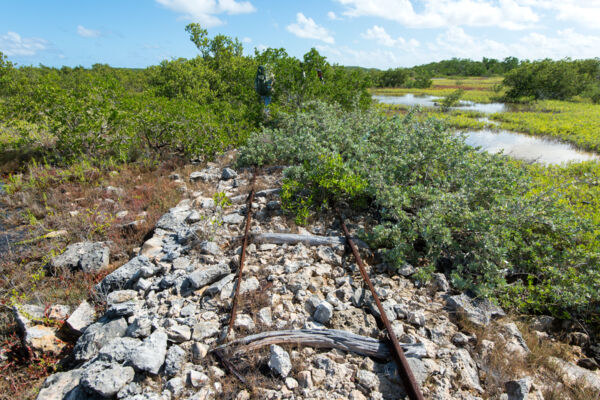
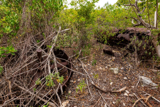
The largest caves on the island were mined for bat guano, as were the Conch Bar Caves on Middle Caicos. This material was an excellent fertilizer and was exported to be used on the sugar cane plantations in Jamaica and for the production of chemicals.
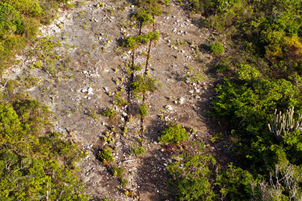
J. N. Reynolds of Ireland carried out these excavations, and due to the moderate success of excavations at Conch Bar Caves, he optimistically constructed an impressive causeway and donkey rail track, along with a dredged mooring area on the west side of East Caicos to facilitate the rapid removal of the guano. Unfortunately for the project, the eventual total output available from the caves never reached expectations, and his focus shifted to raising sisal and cattle ranching.
Jacksonville, Sisal, and Cattle
In the late 1880s, sisal growing was attempted and quickly became the largest export of East Caicos. Sisal (also called pita in the past) is an agave plant that is grown for its very strong fibers, which were used to produce rope and twine. At the height of production, much of the suitable ground was planted, but not for long. Due to poor global demand, competition from plantations in southern Asia, and the advent of synthetic fibers, the industry was abandoned on the island by the early 1900s.
In the late 1800s, cattle ranching was also carried out by J. N. Reynolds, and for years was moderately successful. The beef was considered to be quite good, and was especially appreciated on Grand Turk (considering that the alternative usually consisted of canned and/or salted meats). After the abandonment of the island, remnants of these herds existed for decades, but were eventually hunted to extinction. Today, only donkeys can still be found in the wild on the island.
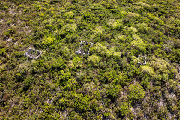
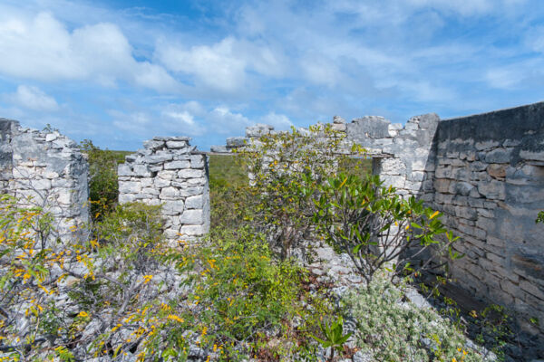
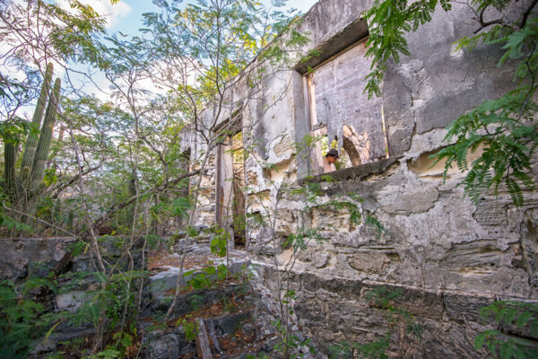
Located on the west end of the island, Jacksonville was the social and economic center of East Caicos. Sisal processing stations, houses, a company store, and barracks capable of housing up to 400 people were all part of Jacksonville. Only a few overgrown ruins remain of this small settlement.
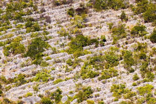
Significant acreage was planted with sisal, yet the infrastructure and field walls were never quite as extensive as what was constructed for the Loyalist cotton plantations on North Caicos, Middle Caicos, and Providenciales.
Small stations and residences were built at various points across East Caicos and the adjacent Hog Cay to facilitate the workings of sisal, guano mining, and the cattle industry, including at Flamingo Hill, Breezy Point, Goods Hill, and on adjacent Hog Cay. Some of these lone stone building ruins still stand in the dense brush. One such site is the Great House ruin on an elevation at Breezy Point, where date palms can still be found growing. Due to seasonal mosquitoes, the common choice for the plantation house was at the height of a hill, where the typical eastern trade winds afforded a little shelter from the pests.
The Ramsar Nature Reserve
The Ramsar Nature Reserve is an extensive protected area that spans much of the southern coasts of North Caicos and Middle Caicos. A region on the western side of East Caicos is part of this nature reserve and conservation area, including a significant section of tidal wetlands, part of the Windward Going Through channel that separates Middle Caicos from East Caicos, Jacksonville Creek, Lorimer’s Point, Iguana Cay, and Flamingo Pond, which is a unique inland tidal pond that has an underwater cave system.
Visiting East Caicos
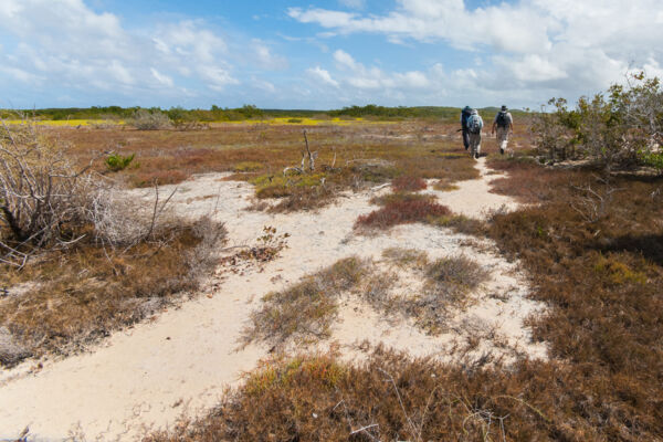
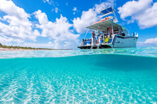
East Caicos is quite remote and is only accessible by boat. Only one business offers expeditions to the island, and due to the low demand and specialty of the excursions, costs can be high. It's highly recommended that you hire an experienced guide if you choose to visit, as the waters around the island can be very difficult to navigate and many points of interest are difficult to find.
East Caicos is an amazing birdwatching destination. There’s a wonderful variety of wading birds, ducks, and tropical dry forest species. The island is one of the larger uninhabited islands in the Caribbean, and the list of endangered plants and birds and endemic Turks and Caicos species found on the island is truly impressive. Sea turtles nest on the expansive coasts.
Because of the many brackish-water blue holes and the small ponds found in the caves, the island at times has huge numbers of mosquitoes, so be prepared.
Tourism and Development
East Caicos experiences extremely limited tourism at present. Various non-government organizations are looking at ways to develop the island for very low-impact tourism. To date, no development projects have been carried out in the present era.
)